
After a quiet night of sleep in Three Mile Canyon, I set my sights on Portland. I didn’t know it at the time, but that would be the last night I would sleep in my tent on my walk.
Part of the reason I had taken the previous afternoon off was to plan out my walk into Portland. Not so much where I was going to sleep, but the best way to go about tackling the interstate ahead.
People had warned me about some narrow stretches on I-84 and several construction zones. I used a combination of Google Satellite and Street View, and Oregon’s Department of Transportation website to plan a route that would make upcoming miles as safe as possible. I memorized which exits to take, where I would follow frontage roads, where I would walk with traffic, and at what mile markers several unavoidable narrow bridges were. The most challenging stretches of the walk would be between Hood River and the east side of Portland, which I would hit three days after leaving Three Mile Canyon.
My 36 mile walk to The Dalles was straight forward. I just had to put one foot in front of the other 76,000 times. I officially entered the Columbia River Gorge Scenic Area a bit west of Rufus and approached The Dalles at dusk. Impressive Mount Hood was visible to the southwest and the massive Dalles Dam was lit up like a Christmas tree as I made my way into town.

Finding a place in a city to pitch my tent was always problematic. After I ate three cheeseburgers, a chicken sandwich, and an ice cream cone, I slept behind some trees with a view of the McDonald’s arch where I just had dinner. I would walk a fine line between bum and simplistic traveler in my final days in Oregon.
Hood River was my destination the following day. After 20 miles on the interstate, I was able to follow the lone stretch of the Old Highway 30 Historic Bike Trail that hadn’t been affected by the Eagle Creek Fire the year before. The trail climbed several hundred feet into the hills surrounding the Columbia River. As soon as I gained elevation, I went from a semi-arid desert landscape into beautiful ponderosa pine forests. Moss covered logs and rocks lined the forest floor. I was transported to a different world in a matter of miles. The views from the trail were incredible, too.

At the high point of the trail, I met a man named Ian who was out for a jog with his three-year-old daughter. He invited me to stay with his family in Hood River. I jumped at the opportunity to sleep inside for a night. Their home was three miles out of the way, but I didn’t mind.
Once I got into town, I headed due south. Downtown Hood River sits on a little bluff above the Columbia. To get to Ian’s house, I had to climb out of the valley floor….again. The road I chose from downtown had a 20% grade. I took a running start but quickly slowed down. I wasn’t sure if I had enough energy to get to the top of the 75 yard hill. I had already walked 30 miles and was beat. PJ and I moved painfully slowly. A family walked past us, clearly amused. I was out of breath but felt like I owed them an explanation. I paused at an intersection. “I am walking across America. These hills suck after walking 30 miles already!” They laughed and approached me.
“I think you dropped something,” the father said. I looked around, confused. He handed me a 20 dollar bill. I thanked them for the donation and pushed harder up the remainder of the hill, not wanting to show my exhaustion.
I arrived at Ian’s house 20 minutes later. The family had a heaping portion of fish and steamed rice waiting for me. I was thrilled.
Ian outside his house bidding me good luck!
I retraced my steps in the morning, heading back down the 20% grade of 12th Street into downtown. I couldn’t walk straight down the hill considering how steep the road was. Gravity worked against me, and I didn’t think I could keep my footing as PJ did his best to race down the hill. Instead I walked down the street “slolam ski style,” carving an S shape on the pavement. I caught a few curious glances from people who were in their front yards as PJ and I slowly meandered down the hill.
Today was a big day. I hoped to get through three of the four sections of I-84 I had deemed as dangerous in my planning. I walked with traffic from mile marker 56 to 51, avoiding a construction zone and blind curve around one of the massive canyon walls. The worst part of that stretch was a half mile section where PJ’s left tire was inches inside the white line. To my right was a guardrail and the Columbia River. There was nowhere to bail. I put my life into the driver’s hands. I let out a triumphant fist pump when we took exit 51.
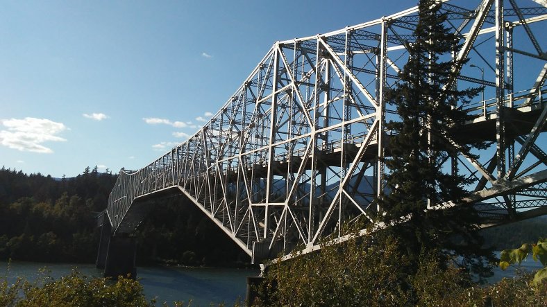
After another 8 miles of walking a frontage road, I arrived in Cascade Locks, home to Bridge of the Gods.
From Cascade Locks, I walked with traffic from mile marker 44 to mile marker 40 to avoid a tunnel on the other side of the road. A lengthy bridge (which, fortunately, offered a wider shoulder) was unnerving to cross but was certainly safer than a dark tunnel given the amount of traffic. I was through obstacle two of four.
The next two hurdles were a pair of shoulderless bridges. They weren’t terribly long, maybe 60 or 70 yards, but given holiday traffic levels (it was the Friday before Labor Day weekend), my best hope was to cross them at dusk or dawn.
I arrived at the first bridge at dusk, waited for a gap in traffic, and ran. PJ’s front tire started wiggling uncontrollably halfway across. “Not now PJ!” I yelled. I had to slow down to get the tire rolling true again. I sped walked the rest of the way. A semi approached 10 feet from the edge of the bridge. He moved to my right a few feet while we cleared the end of the bridge onto the safety of the shoulder. “What a rush!” I hollered. “Whoooooooooo!”
There was one more bridge to go, but it would have to wait until morning. PJ and I walked another five miles on a frontage road and ended the eventful day at mile marker 35. I slept next to a massive ponderosa pine between the frontage road and a freeway on-ramp.
We tackled the final bridge first thing in the morning. My walk started at 6. I wanted to cross the bridge before the sun came up and started blinding drivers heading east. Four cars passed us on the bridge during our crossing. We avoided any close calls, much to my relief.
“Now we can cruise PJ!”
With Portland 35 miles away, I relaxed a bit, and was even able to play tourist for a few hours with a visit to Multnomah Falls. Most of the waterfalls and scenic viewpoints were closed due to the fire. Guards were stationed 24/7 at all the trailheads and parking lots to ensure people didn’t enter the burned areas, which were about everywhere except for the interstate and the few frontage roads I could walk. The falls were a beautiful place to spend a Saturday morning.

After viewing the falls, I was even able to help a distressed motorist! A guy named Chicoby was having engine trouble. While working on his car, he managed to get a bandana stuck in one of the belts (I’m still unclear how it happened!). With the use of my needle nose pliers, a lighter, and some fine hammering, we got the bandana out. It only took an hour. Over the next 15 miles, I passed another four disabled vehicles. I was of no use to them though!
I said goodbye to Interstate 84 at the Troutdale exit and began my suburban Portland walk. I slept in an urban forest in Gresham. Other than some raccoons scurrying by my sleeping bag at 4 AM (which scared the crap out of me) it was a great spot.
I walked across the Hawthrone Bridge into downtown the following morning. After 15 days and 380 miles of walking since Tekoa, Washington, I was ready for a day off.

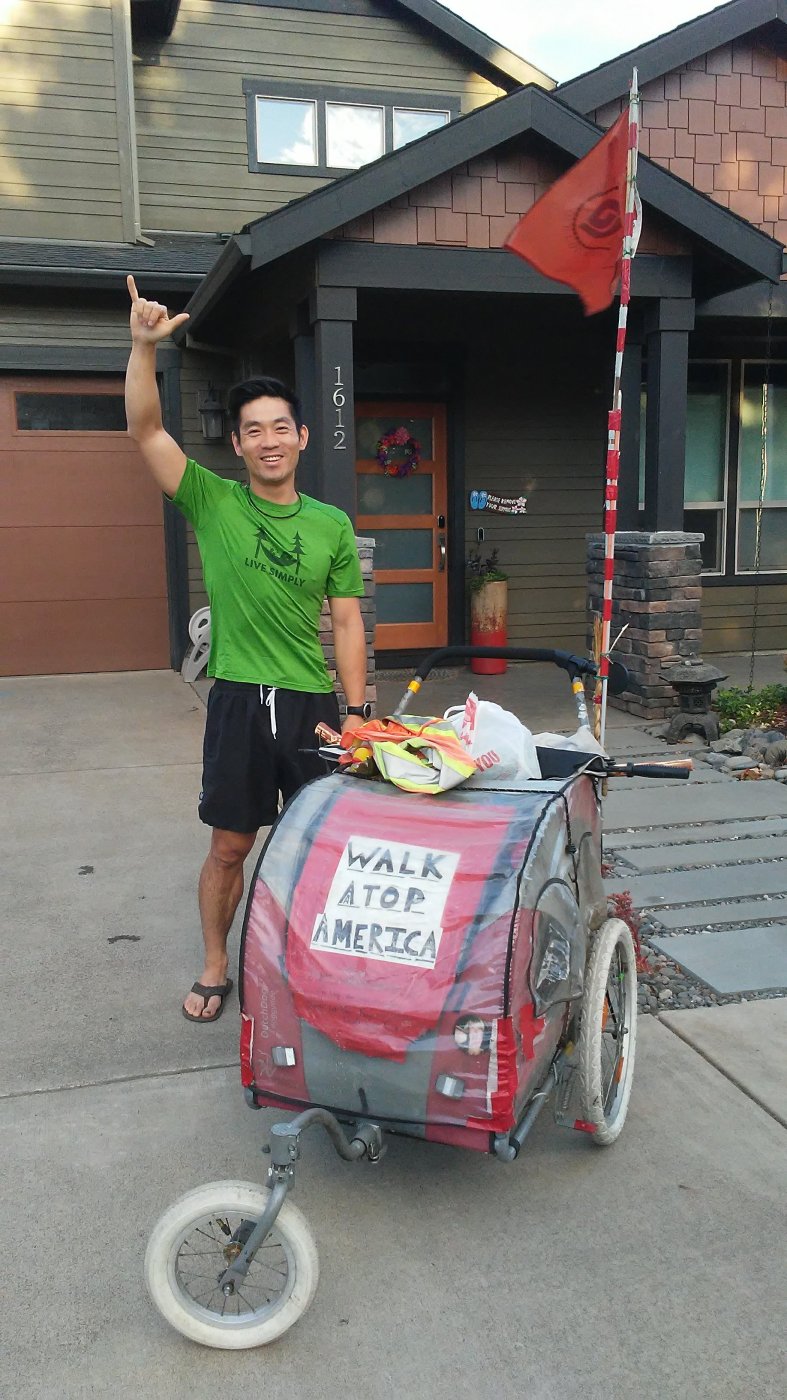
My arrival in The City of Roses meant I had officially walked from Portland, Maine, to Portland, Oregon!
Back when I was having lunch at a Subway in Colfax, Washington, a man named Steve had walked in. He saw PJ outside, and said “Are you walking across America?” We hit it off immediately.
Steve walked across America a few years ago. His journey took four years – from 2012 to 2016. The main difference in our walks – he travelled with a goat! Steve was raising money for an orphanage in Africa. The goats (he actually had two on his trip, Leroy and Miles) maxed out at 10 miles per day. Man did he have some stories!
I stayed with Steve and his wife, Irene (who was part of Steve’s remote support team) for two nights. We had a ball sharing road stories. We also hit some Portland attractions, including Voodoo Donuts and Porter’s Bookstore. After a restful day off, I was ready for my final push to the Pacific.

Steve and Irene outside Voodoo Donuts.
I left Portland on September 4th. Getting out of downtown and into the suburbs was a challenge. Hills just west of the city center, and windy, narrow roads, forced me to walk south before heading west to Beaverton. After 14 miles, I reached the affluent suburb of Hillsboro, past Nike’s International Headquarters, and found a spot to sleep off a bike path surrounded by expensive condos.
I reached Highway 26 the following afternoon, and saw my first sign for Seaside – my eventual destination – 56 miles away! My heart soared.
Dusk approached and I started looking for a sleeping spot. The thick forests were proving difficult to wheel PJ into, and the roads that led into several state forests were gated shut due to high fire danger. No guards, but a gate was enough to keep me out. I settled on a spot off a logging road under some power lines. There wasn’t enough room to pitch my tent in the shrubs. Throwing out my sleeping bag on top of my Thermarest pad (which no longer held air) was my new routine.
I marveled at the Milky Way overhead. Several shooting stars made my grin even bigger.
“We are gonna coast to the ocean PJ!” I said confidently to my buggy before I drifted off to sleep. Highway 26 had been a joy to walk so far. The large, evenly paved shoulder should continue clear through to Seaside. Oregon had different plans.
PJ and I started rolling down the road at dawn the next morning. My plan was to finish my walk on September 8th – my 32nd birthday. 40 miles in two days should be a breeze!
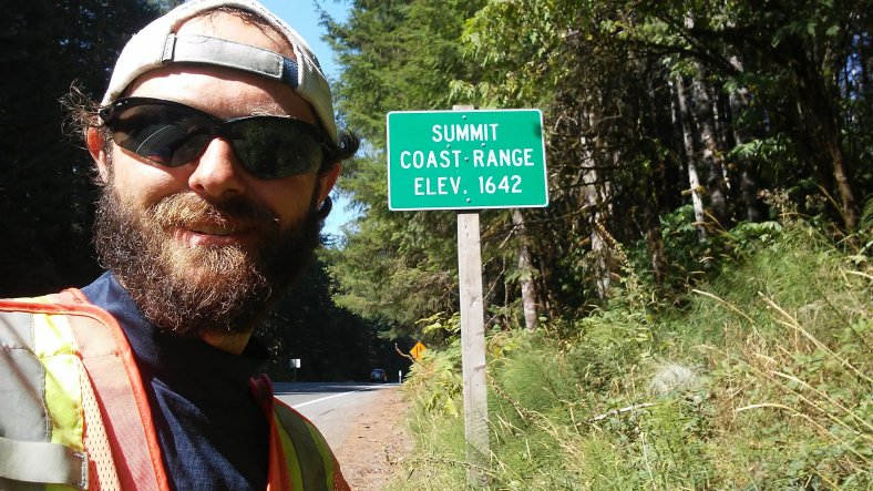
After a few easy miles, the highway began a steady climb through Oregon’s Coastal Range. The mountains weren’t massive, but a 1,000 feet of elevation gain still had my heart rate up. After lunch and a nap at a rest area, we reached the summit of the coastal range at 1,642 feet.
From there, the shoulder quickly dissapeared. PJ and I were faced with “Double G’s” (guardrails on both sides of the road), blind curves, and a new obstacle – shade. The massive trees that lined the highway cast shadows on the road, which would make it a bit tougher for cars to see us, especially when they would drive out of sunlight and into the shade. I lashed my bike light to the handlebars and put it in strobe mode to be more visible. Despite my strobe light, it didn’t feel like much of a party. I darted from one side of the road to the other when approaching a blind curve. Then ran back across when the road briefly straightened out. I wasn’t thinking about how many miles were left. I was too busy making sure PJ and I didn’t end up in the grill of a logging truck.
At one point, I ran over a spring that caused my right tire to go flat. I pushed PJ off the road, moved several six foot logs, and pumped up the tire, hoping it would hold. It would have been a dangerous spot to go through the process of changing a flat. Fortunately, the tire held.
It was a stressful, but strangely fun afternoon.

In addition to some shoulderless stretches, Highway 26 also had a tunnel and a long bridge that were a bit dangerous. Fortunately there was a button to push before entering the tunnel (and crossing the bridge), causing a light to flash to warn drivers of a walker/biker in the tunnel.
After 10 miles of shoulderless walking PJ and I called it a day 22 miles from Seaside. Our last night spent outside was under a canopy of pine trees on a springy bed of pine needles.
I couldn’t wait to get started the next morning with Seaside in sight. PJ and I immediately climbed over one final hill, David Douglas Summit, at a modest 1,300 feet, and began the long, curvy descent into Seaside. It was literally all downhill from there!
I forced myself to stop and take breaks once I was within 15 miles of Seaside. I wanted to slow myself down and really soak in the last few miles of my walk. It was glad I took some breaks to relax because the walking into Seaside was anything but relaxing. The road had widened slightly, but a steady stream of cars left me on my guard. I was less than 10 miles from the Pacific, but might as well have been back in Montana. I chipped away at the remaining miles into town. 9….8….7….6….
“Just get to Seaside. Just get to Seaside.”
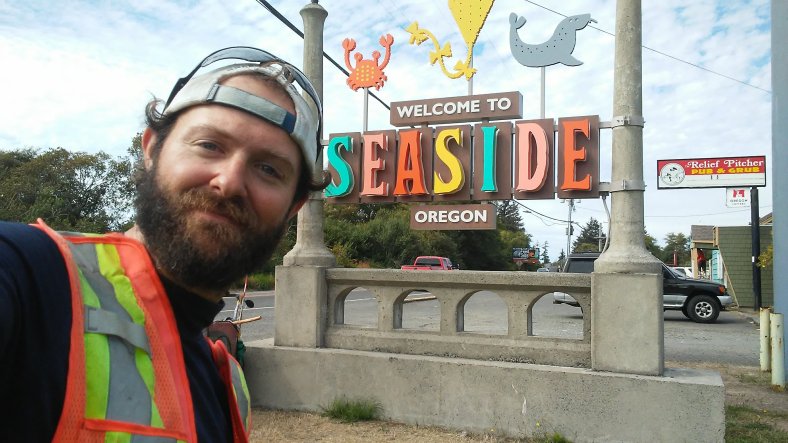
At 3 o’clock on September 7th I arrived at the “Welcome to Seaside” sign. Traffic was so heavy it took 10 minutes to get across the road so I could get a proper photo to commemorate the moment. Passing cars had no idea what I went through to get a picture next to that damn sign!
The Pacific was less than a mile away. I didn’t want to see it yet. My 32nd birthday was the next day. The ocean, and the official completion of my walk, would be my birthday gift.
Trip Stats –
Days – 149
Miles – 3,405
Peanut Butter Jars – 114
Loose Change Count – $9.12
Favorite Roadside Find(s) – Fruit! Blackberries (which are considered an invasive plant in much of Oregon) grew wild nearly everywhere off Highway 26 between Portland and Seaside. When I was low on energy I just stopped and picked a handful of berries! Or as I was waiting for a line of cars to pass before darting to the next “safe zone” on narrow 26, I would snag a few berries and snack next to the highway.
Favorite Three Pictures –

The Columbia River, looking west, from Cascade Locks.

The Richmond Neighborhood in Portland. Looking surprisingly fallish on September 2nd.

Stop and smell the roses – but no picking!
Spoiler alert! I made it to the Pacific! I will be putting together another blog post in the next week detailing my final, eventful mile to the ocean. Steve and Irene took the time to come join me in Seaside on my final walking day. It would end up being one of the best days of my life. The emotions I felt, and some closing thoughts about this amazing journey, deserve their own post.
Walk on!

Thanks Ben for sharing your experiences in the Pacific Northwest. I loved the photo of the Columbia River…very picturesque. Happy belated B-Day! Carry on! Liz
On Mon, Sep 10, 2018 at 2:14 PM Walking Across America – 2018 wrote:
> Ben_Clagett posted: “After a quiet night of sleep in Three Mile Canyon, I > set my sights on Portland. I didn’t know it at the time, but that would be > the last night I would sleep in my tent on my walk. Part of the reason I > had taken the previous afternoon off was to plan out ” >
LikeLike
Thanks Liz! It was a beautiful – but sometimes crazy last stretch! i was certainly happy to be off the interstate!!! Hope you are enjoying the last days of summer in MN!
Ben
LikeLike